By Karen Knapstein
Nearmap has been providing businesses and organizations with aerial data since 2007. Founded in Australia as a small online startup, the company has grown into an international leader in location intelligence and aerial technology, at first only offering aerial surveys and captures; but now providing over 128 AI data layers that automate the identification of 500+ insights.
Nearmap utilizes artificial intelligence (AI) to improve its data, resulting in even better service to users. Kit Revell, Senior Vice President of Sales, explains, “We’re able to leverage machine learning technology to extract data and attributes from our imagery.”
For example, factors such as missing shingles or panels, a temporary repair like a tarp, ponding, or staining. Quickly and accurately identifying condition issues translates into identifying potential re-roofing opportunities for the roofing industry.
Current and Accurate Information
Using current information is critical to the roof proposal process if using aerial imagery. To assure accurate and up-to-date data, Nearmap captures images three times per year (usually in spring, summer and fall) in major metro areas. The frequent image captures allow customers the ability to view a building with leaves on and leaves off in tree-canopied areas. Having frequently captured images is important because if you’re looking at images taken during the summer, when trees were in bloom, you can’t see through the canopy to understand what the structure is like underneath, which forces a customer to go onsite and see with their own eyes rather than viewing imagery,” explains Revell. “The reason why customers select Nearmap as an aerial imagery or AI provider is because of our frequent captures. Having an image from 2015 isn’t as relevant to what they’re needing to do today.”
Accuracy is also a critical feature. Newly developed cameras can see incredibly close detail allowing for enhanced data. The cameras can capture sub-1” imagery; Revell clarifies: “Meaning you can accurately measure the roof from Point A to Point B and be accurate within +/- 1” from the start point and +/- 1” from the endpoint to get an accurate measurement. Customers will leverage accuracy to ensure the quotes they’re creating for their customers are correct, which then will avoid change fees and inaccurate proposals.”


Cape Coral image before damage-causing weather event. Photos courtesy of Nearmap
Cape Coral image after damage-causing weather event, showing temporary roof repairs.
AI’s Input
Revell explains the improvements that AI affords in aerial attributes and data. “As we’re flying over the entire city of Dallas, it’s a needle in a haystack trying to find what building a roofer should target as an opportunity to create a proposal,” he continues. “Customers leverage AI to find that needle in a haystack by leveraging the MapBrowser online platform to show all the roofs that have temporary roof repair.” The result is customers can pinpoint which buildings have temporary repairs, thus targeting which roofs need repairs and focusing on those prospective customers. “Speed is the game. Customers come to us to have a leg up on their competition.”
Post-Catastrophic Data
In addition to the tri-annual imagery updates, Nearmap captures post-catastrophe image data through its ImpactResponse service. “We have a plane in the air usually within less than 24 hours, provided that it’s safe and clear enough to fly,” says Revell. “We’ll process the imagery within hours of the capture and typically have this imagery available to customers who subscribe to ImpactResponse within days of the event.
For example, on Saturday, December 9, 2023, tornadoes ripped through Tennessee, damaging and destroying hundreds of structures. Nearmap had a flight in the air the next day. The imagery was available to Impact Response subscribers on Monday, December 11, and the AI was available on Tuesday, December 12.
The company has a team of about 20 people, who are part of the Nearmap Survey Operations team, and are constantly monitoring the national weather system and all known public sources of weather data to discern weather events and their severity through the Proactive Capture Program. Once they are aware of an event, they start deploying resources around the country to capture the imagery and process the data. “We have about two dozen people who are dedicated to capturing the information that’s important to our customers,” Revell reveals.
Generally, Nearmap focuses on capturing imagery in heavily populated areas. However, if an event is severe enough, they will also cover rural areas. For example, a year or two ago, a tornado tore its way through four states, with much of the path being rural. Since it was such a significant event, they covered the entire destruction path.
AI is Improving All the Time
While AI plays a role in the data process, it’s not fully automated. They’re constantly making improvements to their AI. Currently in its fifth generation, the sixth generation is due to be available this summer. It will focus more on commercial properties with enhancements made for residential properties.
Relevance, speed and accuracy: Because it provides up-to-date, accurate imaging, data, and AI-driven analysis, Nearmap can help roofing companies identify locations in need of their services.
EagleView Launches RapidSOS Integration
EagleView and RapidSOS have announced an integration of EagleView’s high-resolution orthogonal imagery into RapidSOS Premium. EagleView is a provider of aerial imagery, software and analytics, and RapidSOS is the intelligent safety platform securely linking over 500 million devices to more than 16,000 first responder and 9-1-1 agencies.
EagleView’s proprietary camera systems capture superior quality imagery compared to standard satellite images. These detailed images offer higher resolution, greater spatial accuracy, and a clear date stamp, providing critical context in emergency situations.
“Our collaboration is dedicated to one crucial goal, and that’s keeping field responders safe and saving lives,” said Joe Oddi, Director of Partner Strategies at EagleView. “By integrating EagleView imagery with RapidSOS Premium, we help public safety professionals respond in the most accurate and efficient way to citizens in distress.”
RapidSOS Premium enhances the 9-1-1 response system by consolidating critical data such as real-time location, local GIS data, and caller profiles into a single, comprehensive mapping solution. This integration with EagleView will enable RapidSOS users to access high-resolution aerial imagery directly in their workflow, offering unparalleled insights into emergency locations and streamlining decision-making for telecommunicators and field responders.
“Through this alliance with EagleView, telecommunicators can provide more accurate intelligence and directions to support their field responders,” said Karin Marquez, Chief Public Safety Brand Officer at RapidSOS. “With high-resolution aerial imagery in RapidSOS, public safety officials can make faster, smarter, and safer decisions to aid those in the field.”
How AI Can Help In The Quoting Process
By Rick Zand, Content Specialist, New Tech Machinery
Artificial Intelligence (AI) can produce job quotes for customers by calculating multiple aspects of a roofing project. AI analysis can consider material costs, detailed roof measurements, weather and climate conditions, labor costs, and other factors to produce near-exact customer pricing. It can even predict future maintenance costs based on the given information, such as environment, roofing systems, and panel type.
Further, AI can analyze worker productivity based on previous jobs as indicators of future performance. This biometric can help factor in job time and labor hours needed to complete a project. Also, it can factor in transportation, incidentals, and other expenses to better inform the estimate.
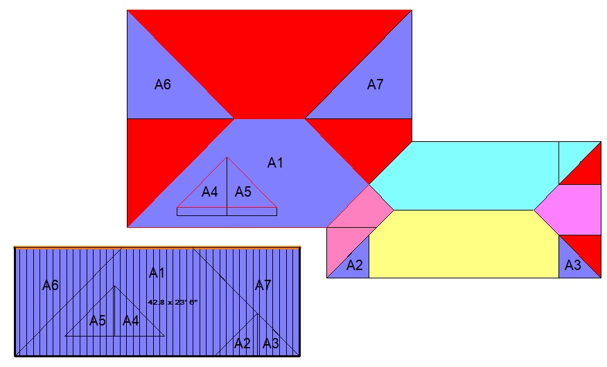
Emerging AI systems can diagram roof slopes, including pitch, ridges, eaves, valleys, and other variables via drone footage or satellite imagery. Already, start-up roofing service companies have begun providing drone services with roof analysis, measurements, and detailed schematics. For one service, the contractor captures the drone footage and feeds it into a proprietary software system, which then identifies roof characteristics and highlights any points of damage. These measurements can provide precise panel measurements for reliable quotes.
AI technology saves time by providing exact measurements so the contractor can provide an accurate, detailed quote and arrive at the job site ready to install the new roofing system
MR